Topographical
Advertisement
SOLE Professional v.4 2
SOLE Professional is highly interactive survey and planning software, it is the only software that cover all the survey & planning requirement like contour, traverse, road design , route survey, topographical survey, revenue survey, mining, city surv
Advertisement
TopoMap v.1.2.0.2
TopoMap is a software to download topographical maps in the scale 1 : 25 000 of Switzerland , France and Spain. The maps are downloaded from map servers provided by the public Institutes Swisstopo, "IGN France" and "IGM Spain".
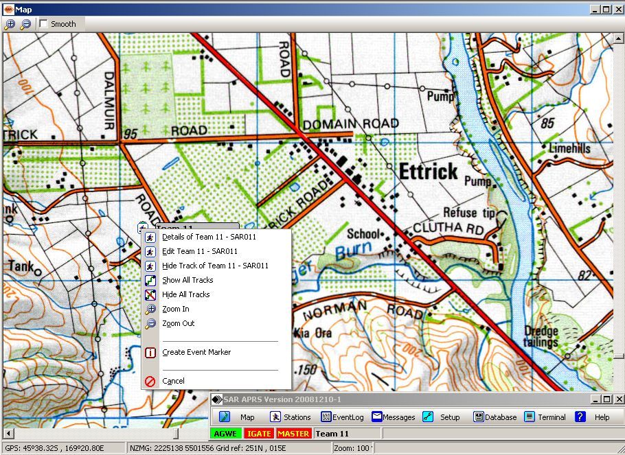
SARTrack 0.9.537 Beta v.1.0
Probably the most important part of the APRS Radio Tracking system, is the computer software program which, amongst many other things, must display the Trackers on a topographical map.
Terrabrowser v.1.5b3
Terrabrowser is an internet browser for satellite photos and topographical maps which are obtained from the Microsoft Terra Server.
TOPOWIN v.16.00
TOPOWIN is a state-wide register of the German topographic cartographies and of localities with geo references in different coordinate systems. It also is a topographic information system.

Geo Data German Admin v.15.00
The database contain geodata of the Federal Republic of Germany with geo referenced towns, municipalities, town quarters, administrative units, postal codes, telephone preselections, nature areas, landscapes, climatic zones for proximity searches ec.

Geo Data Germany v.15.02
The database contain geodata of the Federal Republic of Germany with geo referenced towns, municipalities, town quarters, administrative units, postal codes, telephone preselections, nature areas, landscapes, climatic zones for proximity searches ec.
Fallen Earth v.1 9
Fallen Earth is an MMO game. The action takes place in a post-apocalyptic wasteland located around the American Grand Canyon.
EasyPlan3 v.3.0
This software developed for desktop/laptop PC is a must have for all pilots.
Intricad GRASP 3D Scanner v.1.0
GRASP 3D is a 3D topographic scanner that allows you to scan in objects in 3D using a video camera, a laser line that is swept over the object by hand and some basic materials. Its technology is easy to use with minimal reliance on hardware.
Fugawi Global Navigator v.4.5.50.5002
Fugawi is a strong bitmap-to-use maps in combination with a GPS receiver. Fugawi offers the capability to calibrate with precision digital maps or scan paper maps. You can also import a large number of official or commercial mapping products.